Travelling directions
Flying
Nearest airports are Rome (3 hours driving or about 5 hours with public transport), Ancona (less than two hours driving), Bologna (two and a half hours driving), Pisa is about 3:30 hours driving and Florence (about 2:30 hours driving). Recently Perugia (one hour driving) has been connected directly with London Standsted, Barcelona and Bruxelles.
If you are a group, we can arrange for a minibus to come and fetch you in the airport. In any case, we can help you to find the best way to get here.
Driving
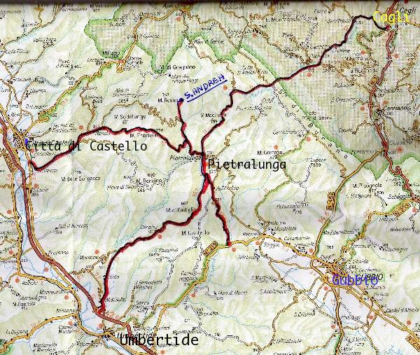
From Florence: Highway to Arezzo, from there follow the signs first to San Sepolcro and then to Città di Castello. Once there, follow the direction "centro" go around the ancient walls of the town keeping them at your left and passing four roundabouts in total. At the fourth round about turn right (first exit) following the direction "Gubbio", go straight 1 km until on the left you find the sign “Pietralunga”. Driving about 19 km in that direction you will find the sign 'S.Andrea' on your left. Follow it. 5 km more, four signs in wood with written "S.Andrea" will show you the right way. Last 400 mt are not asphalted.
From Milan or Venice: Highway until “Cesena nord”, then E45 toward Rome until the exit "Città di Castello nord". Once there, follow the direction "centro" go around the ancient walls of the town keeping them at your left and passing four roundabouts in total. At the fourth round about turn right (first exit) following the direction "Gubbio", go straight 1 km until on the left you find the sign “Pietralunga”. Driving about 19 km in that direction you will find the sign 'S.Andrea' on your left. Follow it. 5 km more, four signs in wood with written "S.Andrea" will show you the right way. Last 400 mt are not asphalted.
From Rome: Highway to Orte, then follow the direction Perugia and Cesena , exit at Montone - Pietralunga and follow the signs to Pietralunga. Once there, immediately after a "Robi" petrol station, turn left for Città di Castello. Follow this road for 2.5 km. A sign on your right will show the way to 'S.Andrea'. Follow it for 5 km more. Four signs in wood with written "S.Andrea" will show you the right way. Last 400 mt are not asphalted.

